2

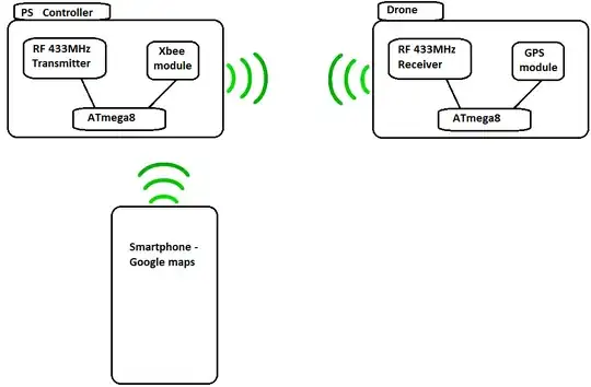
I want to make a drone project, and to that I will use arduino as the platform. My plane is to use a Play Station controller to control the Drone in the air. In addition to that I want to connect a GPS-module. My question goes, is it possible to transmit the longitude and latitude from the GPS via the RF 433MHz to the receiver? When received the longitude and latitude how can I transmit them further to the Smartphone and display the data on google maps? I suggest it could be possible through the Xbee, but I am not sure.

I would like if someone can confirm my idea, if not bring me a better way to do that.

In the image below, you can see the diagram of my design.

Image

AdiT
  • 125
  • 1
  • 1
  • 4

2 Answers2

2

If you are using Xbee modules in your project, why add 433MHz RF, just for the sole purpose of transmitting the location? With the 433Mhz, you will have to implement error-correction yourself.

0

Your design suffers several redundancies that should be fixed. First of all, you have an Xbee (only one, not a pair) and a a 433 MHz transmitter/receiver combo. Why not just add another Xbee to the drone and remove the RF combo? That would save a little battery life for the receiver end, and a lot of your time. You'll also get two way communication with error checking. Although an Xbee would increase your project size a little, if you manually wired the Xbee instead of a shield (3.3V), it would save a lot of space.

As some people point out, Bluetooth is a viable option that's fairly small and low cost. However, it would suffer shorter ranges and it would need a special configuration on the host side for a BT stack.

Anonymous Penguin
  • 6,365
  • 10
  • 34
  • 62